NaviSmart
Real-Time Tactical Sailing Telemetry
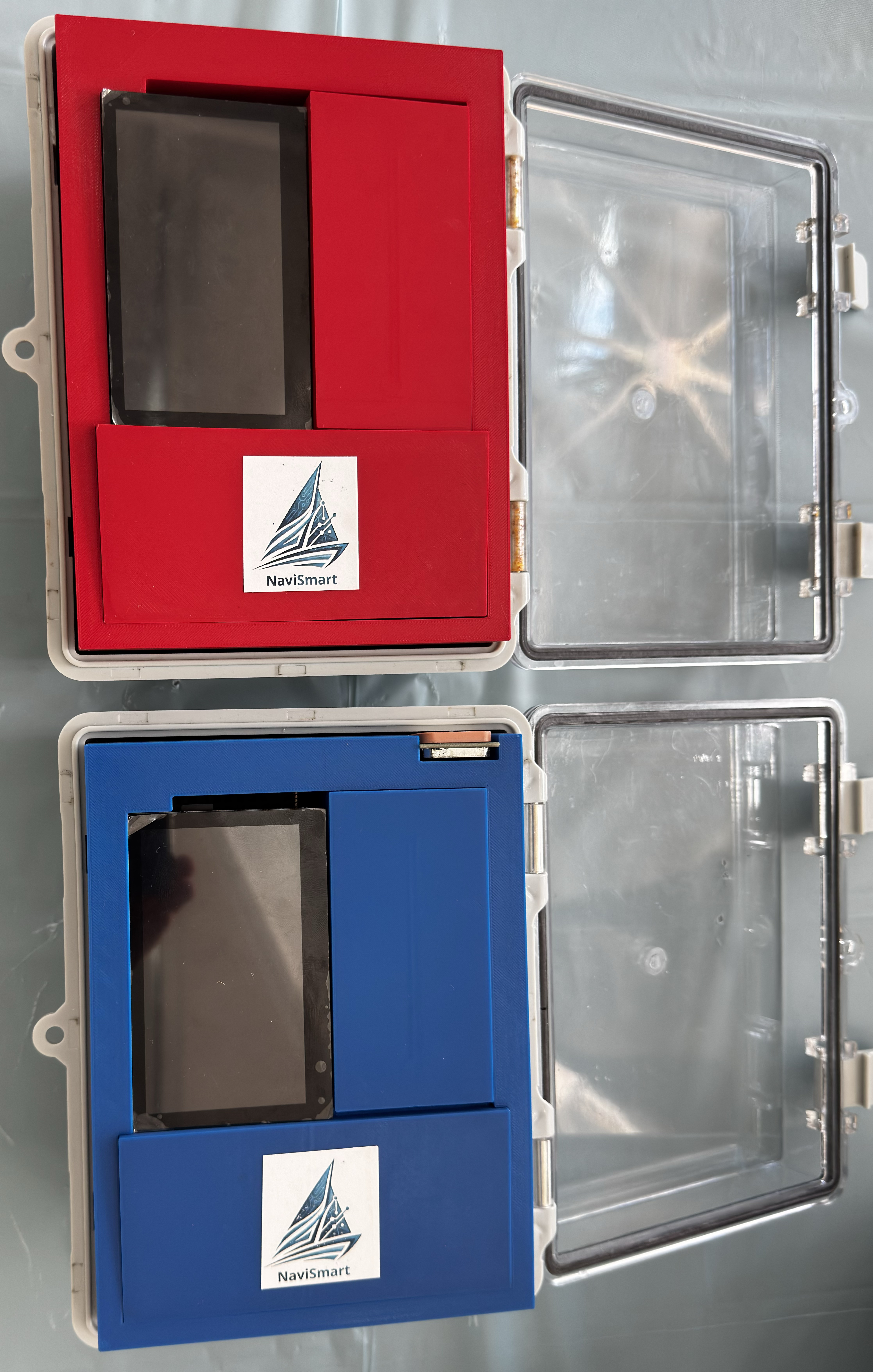
The NaviSmart is an affordable, high-precision onboard monitoring ecosystem engineered for the rigorous demands of sailing. It bridges the gap between high-end professional equipment and accessible training tools, turning raw dynamic data into actionable insights.
By integrating aerospace-grade inertial sensors, NaviSmart captures essential performance metrics instantly. Athletes and coaches no longer have to rely on visual intuition, they can execute data-driven tactical corrections live on the water.
- Live Telemetry & Data Transmission
- High-Frequency Dynamic Sensing
- Uncompromised Accessibility & Disruptive Pricing
- IP67 Marine-Grade Hardware
Technical Specifications
Connectivity
- Wireless Data Gateway: An innovative onboard web server architecture. Post-session, the microcontroller raises a dedicated local Wi-Fi Hotspot, allowing coaches to wirelessly download CSV telemetry logs directly to their devices.
- Long-Range RF Link: Utilizes the nRF24L01 + PA + LNA modules with an external antenna, pushing the amplified 2.4GHz signal up to 1000m to cover massive regatta areas.
- Deterministic Ultra-Low Latency (< 2ms): Isolates critical radio telemetry by packaging data in highly compact byte structures (32 bytes/burst) with hardware-level CRC validation, ensuring 20Hz live streaming without dropouts.
Sensing Unit & Processing
- Asymmetrical Coprocessor Architecture: The system distributes the workload across two microcontrollers. A dedicated real-time RISC-V coprocessor (ESP32-C3) handles high-speed sensor acquisition and RF bridging, while the main ESP32-S3 manages the display and SD data logging.
- High-Visibility Tactical Dashboard: Powered by the MaTouch ecosystem, featuring a 4.3" Parallel TFT IPS display. It provides an ultra-bright, glare-free visual interface designed for passive reading under direct sunlight.
- Independent GNSS: Utilizes the NEO-M8N UART module with a 90-degree mounted ceramic antenna. It ensures stable Speed Over Ground (SOG) and location tracking across global networks without relying on mobile cellular connectivity.
- 9-Axis Smart Sensor Fusion: Features the BNO055 intelligent IMU. Unlike standard raw sensors, it features an internal ARM Cortex-M0 processor to perform on-chip sensor fusion, delivering ultra-precise, pre-calibrated Heel, Pitch, Heading, and Yaw metrics.
Power & Build
- Isolated Power Delivery: Beyond 100µF electrolytic bypass capacitors, the RF and sensor modules are powered by a dedicated Low-Dropout (LDO) linear regulator. This completely isolates the critical communication lines from the voltage spikes generated by the screen's backlight.
- Maritime Endurance (IP67): Rugged hardware specifically designed for harsh saline environments. Housed in a sealed polycarbonate enclosure with a 'Zero-Hole' mechanical policy, ensuring total waterproof insulation and high tolerance to intense sailing vibrations.
Competitive Edge
| Feature | NaviSmart | Traditional Solutions |
|---|---|---|
| Telemetry Latency | 2 ms (Instantaneous) |
N/A (Post-session download only) |
| Transmission Range | Up to 1000m (Radio Frequency) |
Bluetooth Limits (~30m) |
| Data Acquisition | Multi-Constellation GNSS (+ 9-Axis Sensor Fusion) |
Single-Network GPS (Basic Positioning) |
| Installation Process | Non-invasive (Plug & Play) |
Complex (Hull Drilling) |